One Map Policy Acceleration (PKSP) is an effort to create a thematic map that serves as a reference for improving IGT data for each sector as well as a reference for planning large-scale integrated land use in the Spatial Planning document.
PKSP is mandated in Presidential Regulation No. 9 of 2016 and is part of the Economic Policy Package VIII. PKSP is the solution to respond to various challenges and obstacles during the development process, which often leads to overlapping land-use conflicts.
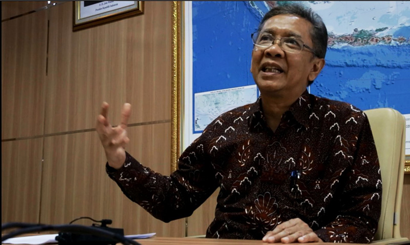
On 6 February 2020, President Joko Widodo chaired a Limited Meeting to discuss the Acceleration of One Map Policy (KSP). Check out our brief discussion with the Head of the Geospatial Information Agency (BIG) Hasanuddin Zainal Abidin regarding limited meetings and their impact on programs implemented by BIG.
What was the Limited Meeting's main discussion?
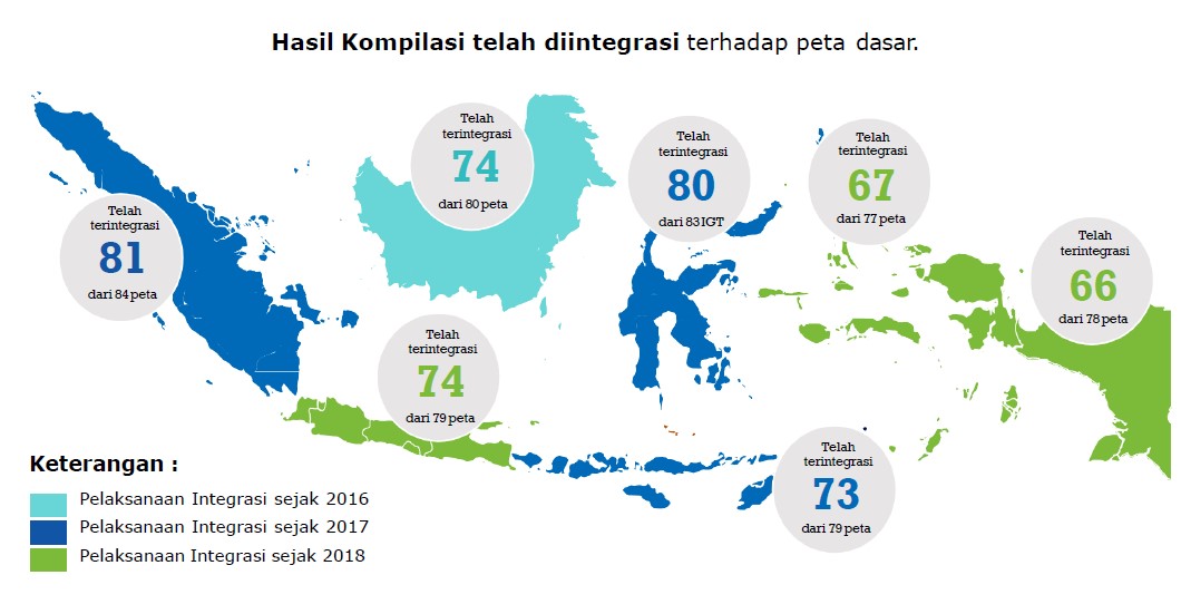
The President said, first, the One Map Policy was almost complete from 85 Thematic Geospatial Information (IGT), 84 of which were already integrated and already in geoportal. One IGT that is not yet a village administration map. Interestingly, the President requested that by the end of 2020, all villages and villages have a definitive boundary.
Well. That is the responsibility of the Ministry of Home Affairs and the region. BIG itself has completed the indicative boundary map; by 2019, 80,308 villages have been completed. But those who already have local regulations (definitive), are still less than 400. The President reminded that.
To achieve this target, what is BIG's responsibility?
We must help the region. The Minister of Home Affairs also said that the problem with budgeting is in the areas. And sometimes some areas didn't have a budget. That's the bother.
Yesterday it was discussed whether the solution would be through the Ministry of Health. Or it could be through the ATR / BPN Ministry; they have a Complete Systematic Land Registration (PTSL) program. Whether we provide the indicative map, then at PTSL confirmed. But it hasn't been decided yet. What is clear is that the President asked for December 2020, all villages have definitive boundaries.

Besides that, what else is the direction of the President?
He delivered directions so that all integrated data should be accessed by ministries, institutions, and regional governments through one geoportal. So don't go anywhere, there must not be too many portals. He stated that: one reference, one standard, one data, and one geoportal.
President also said ministries and regions have to optimize the use of KSP maps for development planning, synchronization, resolution of conflicts over territorial use. Until now, not all of them have access. Only 29 Institution Heads, 30 Governors, and 404 Regents. The percentage reached 76%.
The President wants to encourage ministries, institutions, and regions to utilize these KSP maps.
Third, the President emphasized the overlapping settlement. Now, after compilation, integration, then synchronization. Now, this synchronization is lead by Coordinating Ministry for the Economy; BIG is backing up technically.
The President asked to be fast. Because we already have indicative overlapping maps. The President suggested if you later need legal guidance. Well, the Coordinating Ministry for the Economy will prepare it.
From this directive, what are BIG's responsibilities?
So if we look at the President's direction, now BIG has tremendous responsibilities. Especially in the Strengthening of the National Geospatial Information Network JIGN, the network node, Geoportal KSP. Then Assist coordinating ministry, regions, ministries, institutions to complete this synchronization.
We also reported the progress of the President's direction from the time of the KSP Geoportal launched. One of them is the issue of adding themes because the President asked for it. There are maps of maritime, disaster, and to support the KPK, later the total will be 188 IGT. But we need to revise the Government Law no. 9 of 2016.
Second, a large scale base map, we report we will do a large scale 1: 5,000 mapping. Later on a large scale of 1: 5,000, KSP can be at 1: 5000. We need a lot right now, like for RDTR, RDTR for OSS, investment. Village mapping, infrastructure, agrarian reform. Even smart cities need 1: 1000
To support KSP, this year and in the future, what will BIG do?
We at BIG continue to strengthen Inageoportal, especially the network node. The network node, according to PPIG, is already in all 34 provinces, 150 district cities, 29 ministries, add 21 universities.
So actually all lines must be ready. Basic Geospatial Information (IGD), Thematic Geospatial Information (IGT), and Geospatial Information Infrastructure (IIG).
From the IGD side, we need to update the map. Base map 1: 50,000, 1: 25,000, base maps currently in use. Well then because the President asked to later move to 1: 5,000, yes get ready 1: 5,000.
From IGT standpoint, we need to foster ministries and institutions Because they use our base-maps. There are many IGT data administrators in the department of institutions. Out of 85 IGTs, BIG is responsible for 3. So, BIG through IGT has to foster ministries, institutions, regions so that they can make thematic maps that are under KSP.
From IIG, because the President's direction of access through geoportal must be strengthened, there must be an increase in the quality of the data center and network node. Regional network nodes also need to be assisted, so IIG needs to foster regions, provinces, and city districts so that they can access data, utilize data.
In the future, KSP seems to have increased the need for a large scale, while synchronization has not been completed. Now for large scale KSPs, village boundaries must be finished first. This is a big job for BIG, and I ask all lines to get ready.
